-
 Trekking in Maharashtra, India : 150 Forts
Trekking is an adventure sport which requires physical fitness, endurance, persistence and will power. Man takes delight in overcoming obstacles to see nature at its best. Be in the lap of God.
King Chhatrapati Shivaji (1627 - 1680) has more than 250 forts in his custody, one fourth of the total forts in India. Shivaji built 180 forts and renovated 49 old forts. These hill forts provide plenty of opportunities for trekking.

Western ghats (Sahyadris) is 1700 km long major mountain range in India, runs from Tapi river near Surat in Gujrat to Kanya kumari in Tamil Nadu (Land's end / Cape comorin). It is well known for it's flora, fauna and mountain forts. The famous Ajanta - Ellora caves near Aurangabad is comparable with the entire rock sculptures of a country like France / Italy. Sahydris have numerous delightful routes, both easy and difficult for trekkers of all levels.
Aad (Igatpuri)
Ajinkyatara (Satara)
Ajoba (Bhandardara, Igatpuri)
Alang (Igatpuri)
Anjaneri (Trimbakeshwar)
Ankai Tankai (Manmad)
Arnala (Virar)
Avchitgad (Roha)
Avandh (Igatpuri)
Bhairavgad (Koyna)
Bhairavgad (Malshej)
Bhopatgad (Igatpuri)
Bhudargad (Budhya, Igatpuri)
Bitangad (Igatpuri)
Chandan (Satara)
Chanderi (Karjat)
Chandragad (Mahabaleshwar)
Chandwad (Manmad)
Chavand (Junnar)
Daultabad (Aurangabad)
Dev Dandya (Naneghat, Junnar)
Devgad (near Kudal)
Dhak Bhairi cave (Karjat)
Dhodap (Nashik)
Durga killa (Ahupe, Junnar)
Gambirgad (Dahanu, Konkan)
Gangangad (Kolhapur)
Ghanchakkar (Bhandardara, Igatpuri)
Ghodbander (Mumbai)
Ghargad (Igatpuri)
Gorakhgad (Mhasa, Karjat)
Gawilgad (Badnera, Amaravati)
Hadbi chi shendi pinnacle (Manmad)
Hadsar (Warode, Junnar)
Haji Malang (Kalyan)
Hanumantgad (Nashik)
Hargad (near Mulher, Nashik)
Harihar & Fani Dongar (Igatpuri)
Harishchandragad (Malsej)
Hatkeshwar (Junnar)
Hedruj (Lonavla)
Ikhara pinnacle (Nashik)
Indrai killa (Manmad)
Induri (Talegaon, Lonavla)
Irshalgad (Karjat)
Janjira (Murud)
Jaigarh (Ratnagiri)
Jawlya (Nashik)
Jhungti killa (Koynanagar, Chiplun)
Jivdhan (Ghatghar, Junnar)
Jungli Jaigad (Koynanagar, Chiplun)
Jyotiba (Kolhapur)
Kalsubai (1646 m, highest peak in the Sahyadris, Igatpuri)
Kamalgad (Mahabaleshwar)
Kanchana (Nashik)
Karnala (Panvel)
Kathra (Igatpuri)
Kavnai (Igatpuri)
Kawlya (Bhor, Pune)
Kenjalgad (Wai)
Khanderi (Alibaug)
Kohoj (Manor, Konkan)
Koldher (Chandwad)
Koregad (Lonavla)
Korlai (Roha)
Kothligad (Peth fort, Karjat)
Kulaba (Alibaug)
Kulang (Igatpuri)
Lohagad (Lonavla)
Machindragad (Mhasa, Karjat)
Madangad (Igatpuri)
Mahimantgad (Chandel, Kolhapur)
Mahipat (Mahabaleshwar)
Mahuli (Igatpuri)
Makrandgad (Mahabaleshwar)
Maldev (near Vasota, Koyna)
Manikgad (Panvel)
Mangi Tungi (Nashik)
Manohargad (Sawantwadi)
Mansanthoshgad (Sawantwadi)
Moradi pinnacle (Lonavla)
Muda (Igatpuri)
Mulher (Nashik)
-
150 hill forts of Maharashtra
Padar killa (Karjat)
Palasdari (Karjat)
Padmadurg (Murud)
Pandavgad (Wai)
Panhalgad (Kolhapur)
Patta (Igatpuri)
Pavan khind (Kolhapur)
Peb (Karjat)
Peth (Karjat)
Prabalgad (Karjat)
Prachitagad (Satara)
Pratapgad (Mahabaleshwar)
Purnadar (Saswad, Pune)
Raigad (Mahad, Konkan)
Raireshwar (Bhor)
Rajdher (Manmad)
Rajgad (Welhe, Pune)
Rajmachi (Lonavla)
Rangana (near Kudal, Amboli)
Rasalagad (Mahabaleshwar)
Ratangad (Bhandardara, Igatpuri)
Ratnagiri (Mulshi, Lonavla)
Ravdanda (Roha)
Rawlya (Vani, Nashik)
Sade Teen (Chandwad, Nashik)
Sagargad (Alibaug)
Sajjangad (Parali, Satara)
Salher (1567 m, Nashik)
Salota (Nashik)
Sankshi (Pen)
Saptashringi (Vani, Nashik)
Santoshgad (Koyna, Mahabaleshwar)
Sarasgad (Pali, Lonavla)
Shaniwarwada (Pune)
Shindi (near Vasota, Khed)
Shivneri (Junnar)
Siddhagad (Mhasa, Karjat)
Sindhudurg (Kudal, Konkan)
Sinhgad (Pune)
Sudhagad (Pali, Lonavla)
Sumargad (Mahabaleshwar)
Suvarnadurg (Khed near Chiplun)
Tak Mak (Manor, Knkan)
Taula Achala peaks (Vani, Nashik)
Tel Baila (Lonavla)
Terekhol (Goa border, Sawantwadi)
Tikona (Lonavla)
Torna (Pune)
Tringalwadi (Igatpuri)
Tung (Lonavla)
Underi (Alibaug)
Utwad (Trimbak, Nashik)
Vajragad (Saswad, Pune)
Vandan (Satara)
Varlya - Tillin (Junnar)
Vasai (Mumbai)
Vasota (Bambanoli, Satara)
Vichitragad (Bhor, Pune)
Vijaydurg (Rajapur, Konkan)
Visapur (Lonavla)
Vishalgad (Kolhapur)
Wakri (Bhandardara, Igatpuri)
Trekker's delight : Gorakhgad (Mhasa, Karjat), Harihar (Igatpuri), Harishchandragad (Malsej), Jivdhan (Ghatghar, Junnar), Tung (Lonavla), Vasota (Bambanoli, Satara).
Must see forts : Vasai (Mumbai), Rajmachi (Lonavla), Lohagad (Lonavla), Sinhgad (Pune), Rajgad (Welhe, Pune), Kulaba (Island fort, Alibaug), Ravdanda (Roha), Janjira (Island fort, Murud), Raigad (Mahad, Konkan), Shivneri (Junnar), Daultabad (Aurangabad), .
-
My 51 st fort trek in Maharashtra
I started trekking 6 years back at Lohagad fort near Lonavla. It was a long, enjoying, strenous trekking career. On 10 th June 2007, I was lucky to complete my 50th trek of Ankai fort near Manmad. The forts I trekked is given in the above post in brick red color.Trekking test one's courage. When done with responsibility, it is not as dangerous as many people think.
If I should bow my head let it be to a high mountain" - (Maori proverb)
Trek routes >> rock climb
Essential items for trek : Water proof rucksack, sleeping bag, foamed mattress, walking boots, Hunter shoes, raincoat, torch, batteries, flask, lighter, candle, cap, knife, clothes, tooth brush, paste, blanket, towel, woolen socks, gloves, cooking utensils, mug, plate, spoon, goggles, soap, map, travel info./itinerary, tent, heavy woolens, bottled water, ice axe, camera, film, cash, alarm clock, ATM/credit cards.
Food : Biscuits, bread, jam, dry fruits, fruits, fruit juice, chhapati, cakes, butter, sweets, glucose, boiled eggs, boiled potatoes, curd, condensed milk, soup, ghee, honey etc.
Medicine : Medicine for stomach ache, head ache, vomiting, diarrhea, band aid, dehydration (Electral solution), water purifying tablets.
-
Dev Dandya (1295 m), Junnar
From Junnar (90 km from Pune) travel to Ajnawle (24 km). From here one can climb this hill easily. The hill is identified by a small pinnacle like projection at one end. Climb through the gully at the other end to top. An excellent view of Bhairavgad fort on the west, in the Konkan (Malsej).
Trek takes 3 hour. Ajnawle bus from Junnar at 1230 h reaching Ajnawle at 1430 h - road in bad condition. Last bus from Ajnawle to Junnar is at 1700 h. One can stay in the temple at the village. Winter is chilly. Ghatghar (4 km before Ajnawle, Naneghat). Lying on the ridge on the ghats, to the west of Nimagiri, is the hill of Dev Dandya, a trek which could be combined with the former.

-
Shivneri fort (1018 m), Junnar
The fortress was the birth place of Shivaji (1627 - 1680), the great Maratha warrior king. The fort is 3 km from Junnar (90 km from Pune). It has a huge arch at the entrance and well preserved fortifications. The route to top leads via series of entrances. The gates in the fort increases the security. It rises from a three cornered base of about 250 m from the plains and looks over the town of Junnar. Its long and wavy ridge is marked for miles around by an arch, which stands out against the sky between the minarets of a mosque.
On top one can see an Idgah with dome. Lower on the ridge, a memorial to Shivaji, a mosque, water tanks, caves filled with water, Shiv mandir (temple), foundation of the ruined palace, Shivaji's cradle, a buruj - from where condemned prisoners were thrown. From the water tank near the mosque one can climb down to Junnar via an interesting shortcut. After 15 min walk, an exposed rock cut steps (3 m) has to be covered. There one can see 4 - 5 caves, which are visible even from the ST stand. The track climb down to reach the main road. To and fro trek take s 2 hour.


-
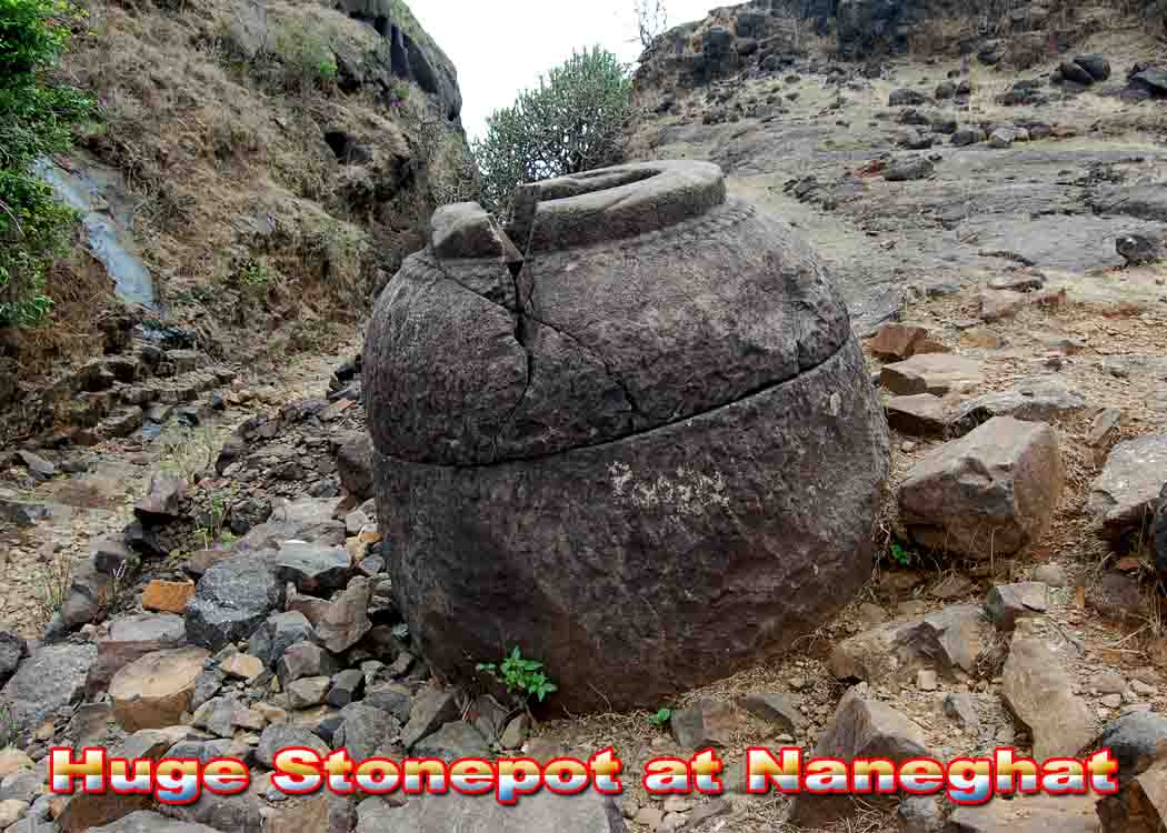
Jivdhan fort (1145 m) & Nane ghat, Junnar
The fort is at Ghatghar with a prominent isolated pillar of 60 m high, known as Vanar lingi. The fort walls near the pillar drop a sheer 1000 m into the Konkan. The path to top of fort is blown off, but has many foot and finger holds artificially made. Top has five water cisterns, some Mohammedan constructions and a commanding view.


Nane ghat (830 m) : This sheer cliff is a well known landmark, very clearly visible from the Konkan. The walls of this pass jut out from the main range and hence command a magnificent view of the great bend in the Sahyadris. To the north one can see Kalsubai, to the south Bhimashankar, to the north east is Harichandragad, shattered pinnacles of Konkan. The great comb like rock of Chanderi and the pinnacles of Haji Malang are also visible.
This is a pass, which, once in history, enjoyed prime importance. At Nane ghat the inscriptions, the steps, the rock cut rest houses and the cisterns show that as far back as 1st century BC, this route was frequently used. Even now, it carries heavy trade traffic. From Ghar ghar, an unmettaled road leads to Nane ghat pass (6 km, one hour by walk). Nice views of Jivdhan fort and Vanar lingi (recently climbed by rock climbers). From Nane ghat one can climb down to Vaishakhare on Malshej road (14 km).
Location : Junnar is 90 km from Pune. Ghatghar is 23 km from Junnar on the Ajnawle road.

-
Janjira fort, Murud
The word ‘Janjira' mean an island fort. However, the term is now used exclusively for the great Siddi fort off the coast of Murud and hence it is often called Murud Janjira. Located at 18º 16' north, latitude and 72º 55' east longitude, it was at one time given the name “Mehar-ruba” or “Mehar-rusa”. The Portuguese called it “Damda”.
The fort was originally built by Rama Koli, under the protection of the Nizamshahi Sultan, in late 15th century. The walls were made from huge logs. In 1617 the command of the fort was given to Siddi Amar by Malik Ambar, the great Nizamshah's statesman. From then onward the Siddis held the fort continuously for over three hundred years. And it is to their credit that Janjira was never captured by any power, even the great Maratha warrior Shivaji failed.
Janjira was a very strong fort with high rampart and 22 bastions. The main gate faces east and is protected by two huge bastions with a gallery on top. An interesting feature of this gate Mabadarwaja – is a sculpture on the walls. It shows a tiger clasping four elephants in its claws and one each in its jaws and tail. There are four huge cannons in the gallery above the main gate. Today, the fort is in ruins but a visit is well worth it because even the ruin give us a good idea of the grandeur of the place in olden times. A walk along the ramparts presents a wonderful view of the sea and the channel and the large area of the fort.
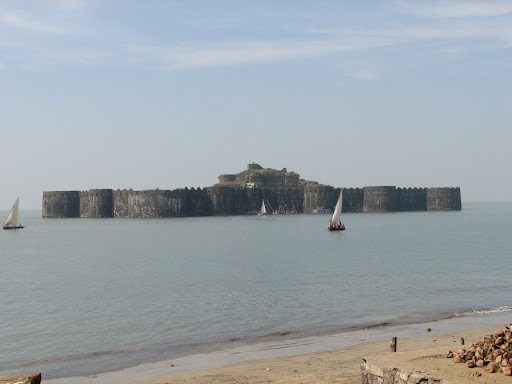


Korlai and Revdanda forts are on the scenic Alibaug - Murud route. Janjira has a nice beach, tasty sea food, the scenic Kashid beach and a gorgeous mansion built by the Nawab of Janjira. An MTDC rest house and a few hotels provide fairly good accommodation.
Janjira island fort with one of India's largest cannons - Landa Kasam ( > 90 cm is in diameter ferried in pieces and welded together in the fort), 12 m high fort walls, palace (in ruins), nearby Padmadurg fort (3 km by boat - built by King Shivaji to observe the activities of the Siddis), Janjira is one of the few forts in Maharashtra, which is in good condition even now. The fort still has more than 60 cannons. Toilets with septic tank is another rare thing in the forts of Maharashtra. The fort has two entrances, of which one is commonly used. The other entrance is difficult to approach by boats as the area is rocky and can damage the vessels severely.
Janjira fort is situated about 2 km into the sea from Rajpuri near Murud. The fort was constructed on an island with two large water tanks for drinking water. The fort can be accessed by wind sail boats which operated from dawn to dusk (Rs 15). Morning time is best to photograph the fort. It was considered impregnable and witnessed many battles during the 300 year old reign of Siddis.
A must see for a fort enthusiast, a tourist, a defence personnel ......... .
Location : Murud is 165 km from Mumbai via Alibaug. Nearest railway station is Roha on Konkan railway.
-
Koregad fort (929 m), Lonavala
The fort is at Ambavne, 24 km from Lonavla is in Pune district. ST buses and jeeps connect the base of the fort. The trek is easy and well defined.
From Ambavne village one can approach the right side of the fort where there is a depression. A track climb steeply via a small forest to top. Get down one km before Ambavne at Peth shahpur and follow the good track on left of the road to fort's base. From here regular cemented steps leads to top. An easy walk takes one to the huge hill top (more than one km long). Just before the fort's entrance, cave cum water tanks and a temple is located. A few more steps leads to the fort's main entrance.

On top, there are 3 temples and 4 big water ponds, 4 cannons, 3 cave cum water tanks, buildings in ruins etc. can be seen. From one end of the fort, nice views of neighboring hill ranges, Mulshi and other lakes, Sahara Amby valley city, Runway of Sahara air terminal etc. Fort has one more entrance and is less used except by devout trekkers and villagers.
Mulshi lake

Climbing down through this route over scree and boulders via steep route. The trek takes 2 hour.
It is said that when the fort was deserted in 1818, the temple ornaments were handed over to Mumbadevi, the goddess of Mumbai. There is an old mortar gun on the top. When Col. Prother of the British forces advances against Koregad on 14th March 1818 this gun was loaded and ready to be fired against the British forces. But the gun charge from the gun blew up the magazine, ruined the gateway and burnt several houses in the fort itself. The fort surrendered immediately.
-
Jungle trek, Koyna nagar
1. Jungli Jaigad
Location : Koyna nagar near Chiplun. Chiplun is on the Mumbai - Goa Konkan railway route.
Jungli Jaigad (901 m) is a small, little known fort near the Koyna dam. Situated in thick forest infested with wild animals. From Chiplun travel to Koynanagar by Karad bus. Then travel to Navja (11 km) via Panchdhara tunnel and follow the road which leads to Alora in Konkan. The road passes at the foot of the fort. The entry to the fort is through a 1 m wide 15 m long route, cracked by an earthquake. The fort is 500 m long and 30 m wide with no water.


2. Jhungti fort : This is an unknown small fort on the western ridge of the Koyna lake. It can be approached from Dicholi village. Dicholi is connected by ferry from Koyna (4 hour), or a walk through thick forest (10 km) is possible via the Jungli Jaigad route. Ahead of Dicholi, the route to Jhungti is complicated an passes through very thick forest. Above Dicholi two huge volcanic rock fields locally known as 'sada' are to be passed. Cross the Vaghul sada and traverse north wards in thick forest. Walking along the ridge of the ghats, reach a high point 1027 m. From here, turn west, up and down a spur to reach Jhungti, jutting out into the Konkan. No inhabitation on the way except wild animals !.
Enjoy the company of birds and animals. Be with nature.
Eye and mind see beauty every where.
3. Vasota fort (1171 m) is located near at Koyna region surrounded by bear infested jungle. It is inaccessible except by a long and ardous trek. It is possible to visit the fort through thick jungles.
Travel from Satara to Bamnoli via Kas lake (34 km) by ST bus to catch a ferry boat. Cross the Koyna lake to reach Met Indapur. Then walk to Khirkundi village. One can reach Khirkundi village from Tapole near Mahabaleshwar by ferry. Walk westwards through thick uninhabited forest. Climb the forested route to top of the fort (5 km) having water tanks and a temple.
My route : A flat walk towards north take one to rock carved Nageshwar temple - a nose like projection having a route to top. A water tank is near by. One can descent to Konkan at Chorvane near Chiplun via Nagsari pass. The route downwards is over steep and exposed scree. The climb through this route is a challenge even to seasoned trekkers. The area is dry and one can get exhausted due to dehydration. Drink plenty of water and Electoral solution for dehydration. To and fro trek takes 9 hour via Chorvane route.
The western side of the Koyna lake from Koynanagar (near Chiplun) to Tapole (near Mahabaleshwar) has plenty of jungle, infested with wild animals. For the adventurous people it will be a treat to trek through the dense forest. The distance of the trek is 60 km and can be covered in 5 days. Permission from Forest authorities required for the trek.
Location : Koyna region of Satara. Routes are from Satara, Chiplun and Mahabaleshwar. Mahabaleshwar to Tapole by bus, to Bamnoli by boat.
Enjoy trekking. Be in the lap of nature.

-
Peb fort (474 m), Matheran
Peb is a small hill fort adjoining Matheran, which is popular with hikers and a day long hikings in rains. From Neral station follow the road via taxi stand to main road (Hotel Divya Deep). Appraoch the base of the fort by following a cart road leading to a village near a paultry farm (3 km). Approach the transmission tower on a hill and a track climbs up to a higher plateau. Further a small track climbs gradually to a saddle. The left track on the sharp ridge takes one to a one metre high boulder fitted with a rope (easy climb). The traverse leads to two caves at the base of the fort and to an iron ladder (7 metre high, fitted). On top there is a water tank and steps. If one is adventure loving, he can follow the steep route to top via steps. The top can be reached by a 10 m easy climb with the help of an iron rope fitted permanently.
The top has Datta paduka mandir/temple and a more than 10 m long saffron flag with 'ohm' on it.Top is barren and is narrow with a water tank near by. From top, there is an easy way on the ridge towards Matheran. On the way there is a Swami ashram where is one can stay a night if desired. Swami has a domesticated dog and having other modern facilities. From Kotwal buruj (fortification with a flag near Matheran), an exposed route leads on to the railway line on Matheran under Panorama point, a water tank, a cave, another vantage points are near by.

Location : Near Matheran / Neral on Mumbai - Karjat/Pune train route. The to and fro trek takes 4.5 hour from Neral. If one is having two wheeler the base village near the poultry farm is accessible by cart road.

 Posting Permissions
- You may not post new threads
- You may not post replies
- You may not post attachments
- You may not edit your posts
-
Forum Rules


 Reply With Quote
Bookmarks