-
 Dehradun to Yamunotri & Gangotri
Dehradun to Yamunotri & Gangotri
MUSSOORIE - Major hill station 28 km from Dehradun, gardens, trekking, Gun hill rope way, Tibettan market, Kempty falls (15 km), Yamuna bridge (27 km), Surkhanda devi temple (35 km).
Access from Dehradun by bus. Dehradun is the nearest railhead with good connections to New Delhi.
Yamunotri (140 km from Mussoorie) - From Hanuman chatti, 13 km trek via Janaki chatti for Yamunotri. Hindu pilgrim centre : temple, hot springs - Surya kund (88oC), Divya shila rock pillar near the temple. Source of river Yamuna (strenuous 13 km trek).
Places enroute
Badkot
Badkot is a small backdrop that places 49 km far away from Yamunotri. This village is famous for one of the earliest temples.
Hanuman Chatti
It is 13 km far away from Yamunotri. The trek starts to Dodi Tal (3,307 m) where the Yamuna and Ganga rivers are come together. Here visitors can prefer Porters and ponies to Yamunotri.
Janki Chatti
It is 7 km far from Yamunotri which is very famous because of there natural hot water where visitors generally take bath.
Surya Kund
Surya Kund is the most important and well famous sacred kund of Yamunotri in the middle of the bunch of thermal springs in the surrounding area of the temple which flows into frequent kund. Pilgrims take raw rice and potatoes and knot in a cloth, and dip it in the water to be prepared. After preparing the food pilgrims serves as a Prasad. This Kund is named by Lord Surya the father of goddess Yamunotri.

Divya Shila
An Enormous rock pillar recognized previous to incoming the Yamunotri Temple.
Saptrishi Kund
This is the basis of Yamuna but creature a small complicated to right of entry; few people go there and most hold out their hope in the temple itself. A twelve km difficult trek way will obtain you to Saptrishi kund. The trip to Saptrishi Kund desires you to be become accustomed for at least one day at Chardham Yatra - Yamunotri and a guide to take you.
Road route : Dehradun - Mussoorie - Nainbagh - Kuwa - Naugaon - Barkot - Rajgarhi - Kotnur - Yamunotri.
Gangotri (120 km from Yamunotri at 3048 m) - Hindu pilgrim centre : temple, Open May to October. Mussoorie to Lanka (112 km).
Trek to Gangotri (11 km), to Bhajbasa (3800 m, 12 km) via Chibasa , to Gaumukh Glacier (3970 m, source of Ganga river, 12 km trek) and back.
Nandanvan
Nandanvan is a 6 km rough trekking path all along the glacier and provide a sight of the Shivling. Across the snout of the Gangotri glacier is the sylvan Tapovan, which is known for its exquisite verdure encircling the base of the Shivling peak. From here, one can go to Vasuki Tal, Kalindikhal, at a height of 5590 meters and reach Badrinath.
Kedar Tal
Kedar Tal, the stunning and charming mere is to be found at a distance of regarding 18 km from Gangotri.
Gaumukh Glacier
The Gomukh Yatra which is 19 km far from Gangotri is at an altitude of 4,255 m on the foothills of the Bhagirathi series. The entire draw out has to be roofed on foot although horses, coolies and guides are to be had. Ganges is one of the holiest river in India and its foundation, a sacred pilgrimage for religious Hindus. The hike follows the Ganges to its basis at Gaumukh; this is source of river Ganges.
Sahasradhara Waterfall

Cheedvasa and Bhojvasa
From Gangotri is Cheedvasa at a detachment of 28 km. Bhojvasa is at a detachment of 22 km; both are a perfect campground location.
Road route : Barkot - Dharasu - Genwala - Uttarkashi - Maneri - Maala - Bhatwari - Raithal - Gangnani - Sunagar - Harsil - Dharali - Lanka - Gangotri.
-
Chardham Yatra : Kedarnath
Chardham Yatra : Kedarnath
Rishikesh - Located near the Haridwar railhead. Has good bus connections to Kedarnath (222 km) & Badrinath (300 km).
Kedarnath - Hindu pilgrim centre (180 km from Rishikesh, 3584 m, 13 km trek from Gaurikund (1981 m, hot springs) - 12th jyotirlinga Shiv temple, May to Oct), Shankaracharya samadhi, Chaukamba glacier (2 km). Gaurikund & Kedarnath has limited basic accommodation. Ponies are available on the Gaurikund - Kedarnath route. Ticket has to be taken for the trek.
Vasuki tal lake (4200 m, 5 km trek, 1 km in dia.), wild flowers, trek with a guide as the route is difficult to find. Paian Tal is 1 km from Vasukital.
Gaurikund
This temple is devoted to Gauri which is trekking base to Kedarnath. This place has hot springs of curative worth are notable.

Shankaracharya Samadhi
At the back of Kedarnath Temple there is a Samadhi of Adi Guru Shankaracharya. It is supposed, after set up the four dhams in India, he take Samadhi in his age of 32 years. This is a smooth display place on the bank of river Ganga where followers perform cremation of their dead intimates.
Chorabari (Gandhi Sarovar)
There is a lake which has a legend that Yudhishthir the eldest brother of the pandavs to have deceased to paradise. The floating ice on the luminous waters of the pond is an attractive view.
Road route : Dharasu - New Tehri - Ghansali - Bhatwari (near Rudraprayag) - Bharamwari - Okhimath - Guptkashi - Phata - Sonprayag - Gaurikund - Kedarnath.
Guptkashi - Gopeshwar - Chamoli- Birahi - Pipalkoti - Joshimath - Govindghat - Pandukeshwar - Hanuman Chatti - Badrinath.
-
Chardham Yatra - Badrinath
Badrinath - Hindu pilgrim centre (300 km from Rishikesh, 12 hour, 3100 m), hot springs : Taptakund and Surya kund (550C), from temple steps leads to Charan paduka. The last village Mana is at 3 km. Vyas gupha : cave, trek to Vasudhara falls via Bhim pul (5 km, 122 m water fall at 3658 m). The route leads to Mt. Nilkantha (6596 m, 10 km). Mt. Kamet (7756 m). China border is just 15 km away.
Tapt Kund
This kund has a natural hot water on the bank of Alaknanda River where visitors take a bath or get refresh before going to temple. Assumed to be instilled with curative chattels, Tapt Kund is also measured to be sacred knowledge.
Charanpaduka
It is a beautiful meadow on which footprints of Lord Vishnu are visible (From back side of the temple steps leads to Charanpaduka). It is a stunning pasture on which footprints of Lord Vishnu are observable. The fast moving clouds below is a great scenic sight.

Above Badrinath, a route leads to the Base of Mt Nilkantha.
Road route : Rishikesh - Devaprayag - Srinagar - Rudraprayag - Karnaprayag - Nandaprayag - Joshimath - Badrinath.
-
Trekking in Uttarakhand
PINDARI - KAFNI GLACIER - Bageshwar to Song by bus (40 km, 1400 m). Trek to Dhakuri (14 km, 2680 m) via Loharkhet, to Khati (2210 m, 8 km), to Dwali (2576 m, 11 km), (a) to Pindari glacier (3353 to 4625 m) via Phurkia (8 km, 3260 m) : 6 day trek. (b) Kafni glacier (13 km, 3800 m) via Byaligar. All places have dak bunglows. Executive Engr PWD Almora is the reservation authority. Season : May/June.


-
Trekking in Uttarakhand
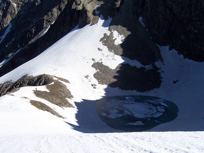
ROOPKUND LAKE (5030 m, also known as the 'Mystery Lake') - Bageshwar to Gwaldam and then to Debal (45 km) by bus. Travel by jeep to Mandoli and then to Wan. Wan to Bedni Bugyal (3350 m, 14 km) : 6 hour. Bedni Bugyal to Bhagwa Basa (4100 m, 5 hour). Then to Roop Kund and back : 100 km , 5 days. Lake is at the foot of Trishul (7122 m) peak. A 30 min further climb take one to Zorawar Gali (5350 m) with great views of glacier and Mt Trishul. The route further steeply climbs down to Homkund, the Nandadevi Jat Yatra route (2012 AD).


-
Trekking in Uttarakhand
MILAM GLACIER (4267 m, length of 27 km and 3 km width) -Bageshwar to Martoli by bus. Trek to Milam glacier (20 km).

SUNDERDUNGA GLACIER - Bageshwar to Song by bus. Trek to Dhakuri via Loharkhet (14 km), to Jatoli via Umla (15 km), to Kathalia (3206 m) via Dungiadong (13 km), (a) to Sunderdunga glacier (7 km, 3800 m) : 7 days. (b) to Sukhram glacier (7 km, 3900 m). (c) Maiktoli glacier (7 km, 3800 m). Tharkot (6100 m), Mrigthuni (6856 m), Maiktoli (6804 m) and Pawali Dwar (6663 m) are nearby peaks.

KHATLING GLACIER/MASARTAL LAKE - Tehri to Ghuttu via Ghansali (63 km). From Ghuttu (1524 m) trek to Reeh (2132 m, 10 km), to Gangi (2584 m, 10 km), to Kalyani (2683 m, 5 km), to Bhelbagi (3110 m, 13 km), to Khatling (3717 m, 7 km), to Masartal (3675 m, 6 km).
Dodi Taal Lake : A stunning addition of water placed at an elevation of 3024 m above the deep level. Bounded by an opaque jungle of deodar, oak, rhododendron and pine, sports look primordial woodland. Base point : Kalyani.
-
Trekking in Uttarakhand
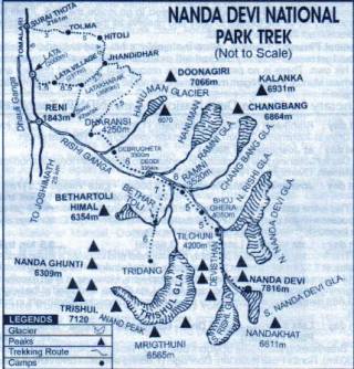
NANDADEVI SANCTUARY - A UNESCO world heritage centre with Mt. Nandadevi (7817 m, India's second highest peak). Joshimath - Malari (70 km) road goes through Tapovan, Reni, Lata (25 km) and Juma. (a) From Malari trek to Niti village (5038 m). (b) Trek from Lata to Dharansi (4250 m, 17 km) and then to Nandadevi sanctuary (40 km) with permit. Joshimath is on the Badrinath road having good accommodation facilities.

 Posting Permissions
- You may not post new threads
- You may not post replies
- You may not post attachments
- You may not edit your posts
-
Forum Rules



 Reply With Quote
Bookmarks