-
 Ghanchakkar (1532 m), Igatpuri
This is a complicated hill, with many ridges and walls on all the sides. It is a place full of crystals, one may be able to collect some beautiful stones.
From Igatpuri travel to Randha falls (50 km, 1.5 h by bus) and walk towards Shirpunje (4 km). A long plod up the barren slopes takes you to the top (4 km). The to and fro trek takes 4 hour.
Randha falls

Pachnai can be reached by bus from Malegaon phata / Randha falls, for Harichandragad fort trek.
-
 Harishchandragad fort (1424 m), Malshej
This is one of the mightiest of the hill forts, situated in a remote location. Travel from Kalyan to Malshej ghat and get down for Khireshwar near a dam (bund cum road). A broad path goes up to the Tolar Khind. A long flat walk leads to the temple.
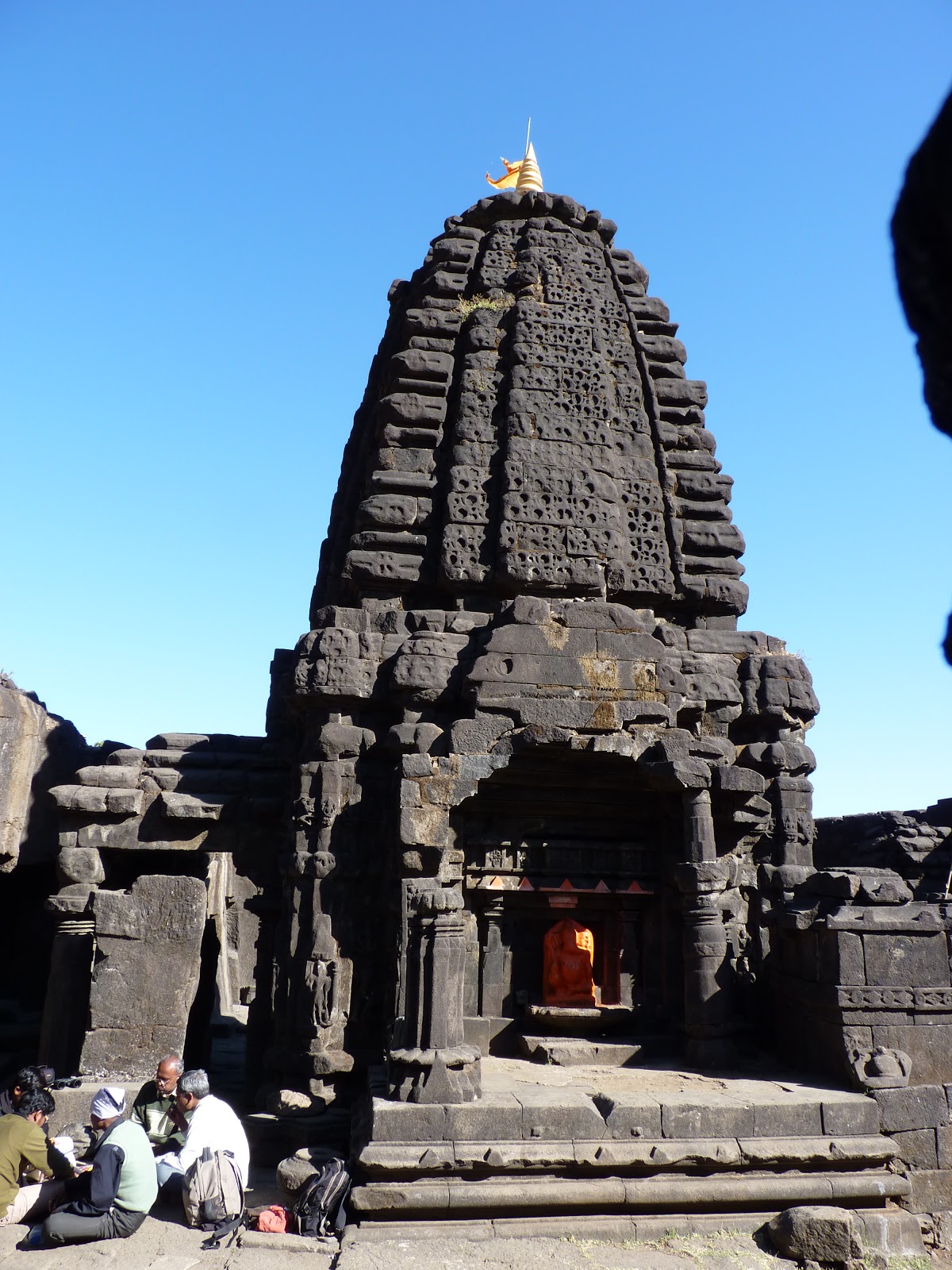
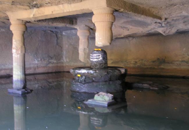
This hilltop has a large water reservoir and a long chain of Brahamanical caves. There is a beautiful temple with water and shelter. Next to the temple is a huge carved out room with a lingi in the centre of a water pond. The actual top is about 100 m further up from the temple and commands a view of the Nane ghat region. On top, a km to the east of the summit is the Bale Killa, with decaying walls and blown up cisterns.


Above, 2 km to the northwest is Konkan Kada. It is a huge semi circular rock wall of about 400 m and is a most beautiful sight. A light object thrown from the top is blown upwards by the strong wind from the semi circular basin.
Harishchandragad surrendered to the British in May 1818. Col. Sykes has written about viewing of perfectly circular vividly coloured rainbow on the edge of the Konkan Kada in mid May. Konkan Kada is a trekker's delight and the experience long a life time.

My friend Maruti Walunj at Konkan Kada
-
 Ghargad (962 m), Igatpuri
Ghargad is in the centre of the range and is difficult to climb. Travel from Igatpuri to Nashik and getdown at Wadhiware phata on the way. Walk to the base of the fort via Wadhiware village (7 km). Follow a rocky staircase, which is blown off in some palces, to reach the top.
A long tunnel at the base of the rocky massif is a mystery and no one knows its length. After descending walk towards right, all along the ridge, to Ambli a rocky peak, to get an excellent view of the Trimbakeswar region. Thumb like 100 m pinnacle Dangya is on the left when one approaches the Ghargad.
-
 Chandwad fort (1125 m)
Reach Lasalgaon railway station ahead of Nashik and travel to Chanwad by bus. Proceed to the small temple on the ridge and the route climbs to the top after a 15 m of rock climb. Rope is advised for the climb.

-
 Indrai killa (1370 m), Chandwad
From Chandwad travel on the NH 3 and get down at Vedbhari (6 km). An 8 km walk leads to Rajdhar village and to a well fortified entrance. There are excellent broad rocky staircases, many caves, a temple and huge water tanks on the top.
-
 Rajdher fort (1091 m), Chandwad
A very interesting and difficult fort. From Chandwad, reach Rajdher village (20 km). A complicated route leads to the base of the rock wall on the rear side of the fort. A 100 m rock climb over the blown off steps leads to the fort. An iron ladder has been fixed to give easy access to the fort.
An anchor is available above the blown off steps to fix a rope for rappelling down or climbing up.

-
-
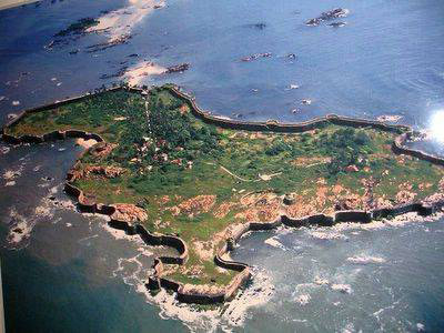
 Sindhudurg sea fort
Fort on a rocky island of Malvan, was the formidable naval base of King Shivaji. He had personally selected the site and participated in its construction. A small temple with Shivaji's image, palm and footprints are on the fort.
The fort is 30 km away from Kudal railway station. The Devgad sea fort is 50 km north of Sindhudurg.

-
 Siddhagad fort (982 m), Karjat
A square massif, standing very prominently detached from the main range. Travel from Kalyan to Murbad and then to Narivali by bus. The route then climbs to Siddhagadwadi (13 km). From the village, the route leads up rather steeply and traverse the whole massif to reach the flat top.
Or Karjat - Mhasa - Jambhurde and then follow the Siddhagad road to the fort.

From Siddhagadwadi, one can go down the southern side to reach Kotwal smarak. Freedom fighter Kotwal was shot at this spot by the British.
-
 Sinhagad fort (1320 m), Pune
From Swargate, Pune to Sinhagad base (Donje) by bus (25 km). If one is having private vehicle, can reach the upper plateau of the fort. Jeeps are also operating for Rs 30 per seat. The road bifurcates little before the Donje village and climbs to the fort. A well defined path leads to Pune darwaza of the fort over a steep ridge (1.5 hour) from Donje.
The fort witnessed many battles during the Maratha period. In 1670 AD Tanaji won the fort for Shivaji. A TV tower with lots of old construction can be seen on the top. The fort has 3 cannons, more than 25 water tanks, 2 -3 temples, MTDC accommodation, other basic accommodation and food huts.
The main places on the fort are Darche Kottar (Amunition Depot), royal stable, Ganesh tank, ancient tank, Tilak Nivas, Rajaram Maharaj Samadhi, Jumjar Buruj, Tanaji Kada (the steep fort wall by which Tanaji Malsure, commander of Shivaji, climbed the fort during night to capture it from Subedar Udai Bhan. He become successful in capturing the fort, but lost his life during the fight), Tanaji memorial , 4 communication towers, Kalavanicha Buruj, Kondareshwar temple, Forest guest house. The three routes from the fort are through Pune Darwaza, Kalyan darwaza and Kalavanicha Buruj.
One can get down through the Kalyan Darwaza to Kalyan village and then to Kondhanpur.
The to and fro trek takes 4 hour.


 Posting Permissions
- You may not post new threads
- You may not post replies
- You may not post attachments
- You may not edit your posts
-
Forum Rules


 Reply With Quote


Bookmarks