-
 Tambolya, Satana
Travel from Nashik - Satana - Taharabad - Selbari phata on the Pimpalner road. Mangi village is 6 km from the main road.From the Mangi village prodceed to Vadkhel and Patalwadi at the base. The climb is sharp.
-
Salota fort, Satana
Travel from Nashik - Satana - Taharabad to reach the base village Vaghambe. Climb to the common col of Salher - Salota.
Proceed to a diagonal rocky staircase in the centre (on the southern wall), leading to the top. Past the staircase the route traverses through caves and water ponds to the top. It has fascinating route to follow.

Salher (1567 m) : From the common col of Salher - Salota, rock steps leads to top.

-
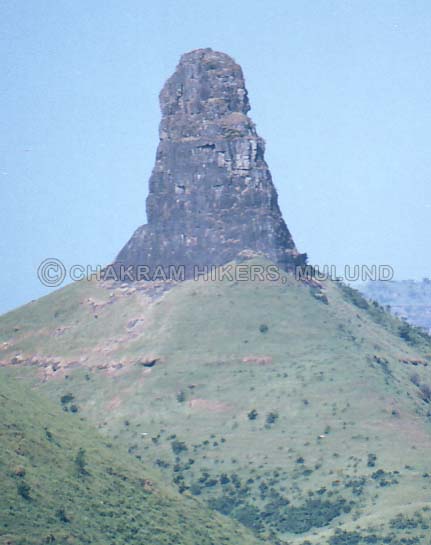
Takara (1478 m), Satana
Takara is a huge pinnacle south of Salher. Prominently visible from Salher - Salota, and the solid massif worth a try. A good climb leads to the top.
From Satana proceed via Vinchur, Sakora and Tatone to Watara at the base (bus available most of the way).
-
Lingana pinnacle (908 m), Pachad
It is an impressive looking mountain near Raigad fort, which is rather difficult to climb. It is advisable to climb with a guide and with climbing equipment. From Mahad travel to Pachad (base of Raigad fort) by bus. Climb down to Linganwadi at the east side.
-
Lingi (540 m), Kalyan
Kalyan to Atgaon by local train. Travel to Tansa lake by bus (13 km). A shapely peak in thickly forested area and it has a wonderful view of Tansa lake.
This is the last point on the ridge jutting out towards Tansa lake from the Mahuli massif. From Tansa dam site proceed through forest to gain its top via the north western (right) skyline ridge. Mahuli Chanderi fort is nearby.
-
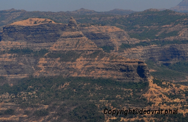
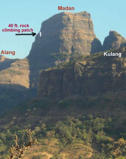
Madangad (1466 m), Igatpuri
This is a difficult fort to reach, recognised by a hole on the extreme right side on top. The top is above the hole and standing over there is an experience in itself. Steps leading to the fort are blown off, so one has to climb the steep rock face of 20 m.
From Igatpuri travel to Bhavli by bus. Trek to Kulangwadi and then to the col of Madangad - Alang. Reach a very narrow and exposed track at the bottom of the rock climbing wall. Someone good in rock climbing has to overcome this difficult and highly exposed section to fix a rope to make it safe for the party. A guide from the near by village is advised. There is a hole carved out in the rock at the top of the climb, which is good for fixing a rope.
Further ahead steps leads to the upper plateau having a huge cave and water tank. There is an excellent view of the neighbouring forts - Kulang and Alang. It is easier to descend by rappelling down. One must be experienced and careful whilst climbing this fort.
My guides & Kulang fort viewed from top of Madangad

-
Alang (1479 m), Igatpuri
Three fourth of the fort had to be traversed, at least 3 times at different levels to reach the top. A series of water cisterns arranged in semi circular fashion on the top is a unique sight.
From Igatpuri travel to Bhavli by bus. Trek to Kulangwadi and then to the col of Madangad - Alang. Descend on the left over rocky slabs to thick forest. A flat traverse enables one to reach almost to the end of the massif. A series of dry water ponds and a giant cracked rock is a marker to turn into a nala for the final climb. A track up the nala leads to small gully. After an easy rock climb supported by a bichki tree one enters the second level of the fort. Another long, flat and some times exposed traverse takes you to the extreme end, towards Madangad. A huge cave is situated here. Above the cave a long traverse gradually climbs to the top. The summit is peculiarly shaped with two small domes. Water cisterns and a small temple are situated at the base of the summit hump.
-
Dangya, Igatpuri
This is a prominent pinnacle, which is clearly visible from the road. Get down at Wadhiware (On Igatpuri - Nashik road) an proceed to Dangya village on the left of the hill range. The 100 m pinnacle has a route from the west.
-
Shenit pinnacle (900 m), Igatpuri
This 60 m pinnacle stands at the saddle of Bitangad. With valleys on two sides it seems very isolated. It would be a very difficult rock climb from the east (facing Bitangad). From Igatpuri reach Warangushi and Shenit village (13 km) by bus, the route passing at the foot of Phandhra all along. On the road from Shenit to Bitangi village, the isolated pinnacle comes in view after 6 km, as you reach the saddle. The rock is quite firm all along but there is also some scree. One can also approach it from Taked via Bitangi in the opposite direction.
-
Napta (1024 m), Igatpuri
Napta is a prominent rocky projection at the edge of the ghats and is visible from many places. It has nose like shape and is difficult to climb. Travel to Malegaon phata by Samgamner bus from Igatpuri. Reach Panchani village by bus. Cross a small depression to reach base of Napta via Pethachiwadi (5 km). Proceed to a col between two peaks of Napta and traverse the southern edge of the main peak. It has about 40 m rock climb and very bad scree has to be crossed. Near the top you find another 20 m of bad scree. There is a great view from the long ridge, which is at the top.

 Posting Permissions
- You may not post new threads
- You may not post replies
- You may not post attachments
- You may not edit your posts
-
Forum Rules


 Administrator
Site Admin
Administrator
Site Admin

 Reply With Quote
Bookmarks