-
 Trekking around Lonavla
LOHAGAD FORT (1040 m) - It is a beautiful fort in good condition near Lonavla. It was captured by Chhatrapati Shivaji in 1648 AD. From Malvali railway station walk to the Bhaje village (3 km). One can visit the group of Buddhist caves located at the base of the fort. Climb to the col of Visapur - Lohagad forts. Lohagad fort is at the right side of the col. A broad route leads through the fortifications to the top. A darga, temple and lots of construction can be seen on the fort. Panoramic view of Pawna dam, Tung, Tikona, Visapur and Lohagad forts.

VISAPUR FORT (1084 m) - Reach the col of Visapur - Lohagad and follow the left track. Trek up through the gully. One can climb down to Malvali from the other side of the fort.

RAJMACHI FORT (828 m) - It is an isolated twin fort on the Bohr pass. The higher fort is called Sreevardhan and the lower is Manranjan. From Lonavla to Tungarli lake by auto (4 km). Walk towards left and follow the road. A 10 km walk takes one to the base village Rajmachi. From the col of these forts a narrow track leads to the top. From Rajmachi one can climb down to Ulhas valley to visit Kondana caves. Cross Ulhas river and climb to Takurwadi railway station on the Karjat route. Trek takes 5 hour. From Ulhas valley one can visit BHAIROBA DHAK (10 hour trek from Tungarli lake) rock cut cave reached after a steep climb over rope - a scenic place with pinnacle and a narrow gully.
KOREGAD FORT (931 m) - From Lonavla reach Ambavne by bus or jeep (25 km). Walk towards the fort's centre. A steep route through the forest (well hidden) takes to top. Get down on the other side of the fort through regular steps. Sahara lake city and Mulshi lake (3 km) are nearby.
SUDHAGAD (620 m) - Take Bhambarde bus from Lonavla and get down at TEL BAILA. The twin pinnacle is a prominent landmark. A 4 km flat walk takes you to base of the massif. A narrow track climbs to the base of rock climbing wall where a temple is located. Tel Baila (1015 m) is a tough and interesting rock climbing route. Rope and improvised ladder are advised. From Tel Baila village get down to Konkan via Wazri pass (2 hour) and reach Dondse village. From Dondse village one can visit Sudhagad fort by following a water nullah and cross it at right. Trek takes 3 hour. Huge gateways and temple are at top. From Dhondse travel to Pali by bus. Tanale and Karsambla caves are nearby.
Tanale caves

TANALE CAVES - From Pali to Tanale by bus (30 min). To and fro trek takes 3 hour. 12 Buddhist caves, bioluminescent tree nearby.
SARASGAD - Pali is famous for Ganesh temple. Track on backside of the temple leads to Sarasgad fort (2 hour). Excellent views of the Pali town from the fort.
-
Trekking around Karjat
PETH (473 m) - Travel from Karjat to Jamrugh and get down at Ambivili by ST. Walk to Peth village and then to Bhairobas's cave. Rock hewn steps leads to top. To and fro trek takes 3 hour.
MATHERAN (768 m) - It is a popular hill station with large number of trekking routes. Neral junction (39 m ASL) is on the Mumbai-Pune rail route. Matheran is 6 hour journey by toy train (13 km) and 30 min. by Taxi. From One tree point one can trek down to Bhorgav via Shivaji's ladder and then to Karjat road in 3 hour. Another trekking route is from Porcupine point to Dodhani village (1 hour) and then to Panvel by bus.
CHANDERI FORT (794 m) - It is a fascinating and intricate looking fort. From Vangani railway station (near Kalyan) travel to Goregaon by auto. Right side road climbs to Chinchavli village (4 km). A right track goes towards a water nullah from a hut and reach the col of Mahasmal-Chanderi. The route is over boulders and is difficult to find. Climb left ridge for the fort. A cave temple is at the base. An exposed and tricky traverse takes you to the centre of the massif. A rocky staircase leads to the top. To and fro trek takes 7 hour.
MAHASMAL (611 m) - From the col of Mahasmal - Chanderi climb right to the base of the pinnacles. Going around reach a narrow col between the second and third pinnacles. Climb the second pinnacle over the scree and boulders. A descent of 10m on the other side and a final climb of 15 m takes one to the top. On descent be careful !
DHAK PLATEAU (708 m) - Karjat to Sandshi by bus or auto. A 10 km climb to the top via Dak village. One can visit Bhimashankar or Rajmachi fort via Bhairoba Dhak cave and Valvande.
BHIMASHANKAR - One of the 12 jyotirlingas is a famous pilgrim centre. Travel from Karjat to Khandas by bus (14 km). 10 km steep climb takes you to top in 4 hour. Shiv temple is on the other side of the rock face. On the way one can see a rocky massif - Padar killa. From the gully between Bhimashankar-Padar killa climb to the top of Padar Killa.
KARNALA (470 m) - Bird Sanctuary with fort on the Panvel-Pen road. Fort has thumb like pinnacle of 50 m, which provides opportunities for rock climbing. Take care of scree and bees.
MANIKGAD (572 m) - Travel from Panvel to Vashivli by ST and get down at Vadgaon phata. Trek to Manikgad village and then to fort in 1.25 hour. Manikgad lingi and Sankshi fort are nearby.
HAJI MALANG (800 m) - Travel to Vavanje by bus from Panvel. Trek to darga of Haji Malang. The Malangad is visible to a long distance. Above the darga there are many opportunities for rock climbing . A thrilling climb takes you to top of the pinnacle via rope bridge. To and fro trek takes 6 hour. Tavli hills (800 m), a group of three pinnacles, is nearby. Tavli caves at the base of the pinnacle can be reached by a tricky and exposed traverse. Another approach is from Kalyan by bus.
MAMA BHANJA - From Thane reach Wagle estate by bus, it has good rock climbing opportunities.
MUMBRA - Near the railway station there is an interesting place for rock climbing, temple.
-
Trekking around MALSEJ
BHAIRAVGAD (866 m) - From Kalyan travel to Morroshi (after Vaishakare). From Malsej Ghat road the pinnacle can be seen. A track at the right side of the road climbs to the base of the pinnacle. To and fro trek takes 3 hour. A formidable rock climb takes to top.
HARISHCHANDRAGAD (1427 m) - Kalyan to Malsej by bus (2 hour). On Malsej ghat get down for fort. The road over bund leads to Khireshwer (3 km). A broad path leads to a gully and a flat long walk takes to base of the fort. It is a remote fort with water reservoirs, temples and caves. There is a cave with large 'linga' at the centre of water. Konkan Kada, a huge semi circular wall of 300 m, is the main attraction. Light objects when thrown are lifted by strong winds. To and fro trek takes 8 hour (5+3).
SHIVNERI (1080 m) - This fortress was the birth place of Shivaji (1637 AD) located 3 km from Junnar. Large arch and minarets of a mosque are visible from a long distance. From the two storied temple one can get down through a steep route (located at the middle of the fort/behind hotel Ashiana on main road). To and fro trek takes 2 hour. From Junnar one can visit the nearby ruined fort. Lenyadri caves are nearby - Astavinayak, pilgrim centre. 12 huge radio telescopes are near Narayangaon.
CHAWAND (990 m) - By Ghatghar/Anjanavale bus reach Kukudeshwar from Junnar. An easy steep climb leads to top (Steel ladder is visible from the road). Ancient temple and water cisterns are on the summit. To and fro trek takes 1.5 hour.
JIVDHAN (1147 m) - Reach Ghatghar from Junnar by bus . A flat walk (3 km) takes one to a ridge at the left side of the fort. From the base of the rock wall left side exposed route leads to the base of Vandar lingi pinnacle (60 m). A steep rock climbing route to the top for professional climbers. Traverse on right side leads to blown away steps of the fort (15 m). It has good foot and finger holds for climbing up. From the top one can see Nane ghat and Vandar lingi pinnacle. To and fro trek takes 3.5 hour.
NANE GHAT/PASS (832 m) - It is a prominent nose like projection when viewed from Malsej road. Nane pass has inscriptions, water cisterns and caves on the way. From Ghatghar walk on the unmettaled road to the pass. A broad route climbs down to Konkan (Vaisakhare on Malsej road, 20 km).
GHORAKHGAD-MACHINDER PINNACLES - From Kalyan/Karjat reach Mhasa by bus (30 km). Travel to Dehri by jeep (10 km). Walk towards the pinnacles over the ridge at right. Ghorakhgad has a huge cave and water cisterns at the base. A steep rocky staircase leads to the temple at top. Excellent views of Machinder and Siddhagad (984 m, access from Nariveli ghat). Trek takes 6 hour except the final rock climb on Machinder.
MACHINDER PINNACLE - From the base of the Ghorakhgad traverse to the col of the pinnacles. Climb over the ridge steeply to top. Final stage (20 m) is rock climb with rope over loose rocks. Go prepared for the climb and be careful while descending.
-
Trekking around IGATPURI
MAHULI (762 m) : There are two formations - Mahuli and Chanderi. The pinnacles can be seen from Asangaon station. Chanderi is tricky and steep with good views of imposing pinnacles. Travel from Kalyan to Asangaon station by train (Kasara). Reach Mahuli village by auto (5 km). A track on the right side climb up the gully in the east face, reaching the saddle at 600 m. The fort has a large plateau having a water tank and excellent views of Tansa lake. To and fro trek takes 4 hour.
Bandaragad fort is near and can be reached by basic rock climbing. Palasgad is at the same plateau.
KULANG (1473 m) - Kulang offers one of the highest climbs from the base. From Igatpuri to Bavli (8 km) by Manveda bus. Follow the road 1 km and take the left track which climb to Kulangwadi (2 hour, one way). Reach the base of the col of Kulang and chota Kulang. Left track leads to a ridge. Climb the ridge via carved steps to top (4 hour trek from Kulangwadi to fort and back). Excellent views of Madangad, Alang and Kalsubai. A huge cave and water cisterns are on the fort.
MADANGAD (1473 m) - The fort has a huge hole at the right hand top. Reach Kulangwadi as in Kulang and approach the col of Alang and Madangad (Shiv Khind). From the col follow the right exposed track to the bottom of the rock climbing wall. After a 13 m rock climb with rope steps leads to top. Excellent views of Alang and Kulang. A cave at good condition at the top. The trek from Kulangwadi to fort and back takes 5.5 hour.
ALANG (1482 m) - Three fourth of the fort has to be traversed in atleast three times. From the col of Alang and Madangad (Shiv Khind) descend on left to the forest. A flat traverse to almost end of the fort and a small rock climb takes one to the next level of the fort. Another long flat exposed traverse takes to the other end of the fort near Madangad. A cave can be seen here and the track climbs to the top. The summit has water cisterns and a temple.
PATTA (1390 m) - Travel to Konkanwadi phata via Taked by Sinnar bus (30 km, 1145 am). Trek to fort via Konkanwadi. Follow the easy 'kachha' road to the temple, 2 caves, a cave cum water tank, a small tunnel and to the top plateau. There is a Muslim style (domed) construction in fairly good condition and few water tanks. One km flat walk leads 12 water cisterns in series and two fairly large caves near the summit. The summit is having an grant view of Avandh fort (1322 m), windmills and lakes.
KALSUBAI (1650 m) - This beautifully shaped peak is the highest peak in Maharashtra. By Bhandardara bus get down at Bari (792 m). An easy route gradually climbs to top. Three iron ladders on the way makes the climb easy. The top is rocky with a fantastic view. A small temple of Devi Kalsubai at the top is legendary and receives many pilgrims. For a change, climb down to Udhavne village on the other side. To and fro trek takes 4 hour.
GHANCHAKKAR (1536 m) - It has many ridges and walls on all sides. By Sangamner bus get down at Randha falls after Bhandardara and walk to Katalpur. A long climb over the barren slopes to top. To and fro trek takes 4 hour.
AJOBA (1378 m) - From Bhandardara lake reach Kalthembe via Muthkel (10 km). Track leads to base of Ratangad and then to col of Kathra. Descend to Kumshet village and reach the base of Ajoba. A zig zag tricky route leads to top. Kathra (1410 m) is between Ajoba and Ratangad fort (1300 m).
-
Trekking around NASHIK
ANJANERI FORT (1303 m) - Nashik to Trimbakeshwar by bus (30 km). ST stand to Anjaneri village and then to fort (5 km).
BRAHMAGIRI (1303 m) - Near Trimbakeshwar. Regular steps leads to the temple at the top. Trek takes 1.5 hour. Harhar fort (1123 m) and Fani Dongar are nearby.
DHODAP (1454 m) - From Nashik/Lasalgaon to Vadala bhoi (50 km) by bus. Then to Dhodambe by truck (7 km). Walk to Hatti village and then to Sonar's village at the upper Plateau (10 km). The top can be reached by a 70m rock climb.
IKARIA PINNACLE (1454 m) - Near Dhodap and it is purely rock climbing route.
CHANDWAD - From Lasalgaon railway station, ahead of Nashik, get Chandwad bus (20 km). A temple is on the ridge and the way leads to top. Access to the fort requires a 13 m rock climb with rope.
INDRAI KILLA (1373 m) - Proceed on Mumbai - Agra NH 3 from Chandwad and follow a cart road on left. 8 km walk and a steep climb takes one to the fort. Caves and temples are at top. Sade Teen is nearby.
RAJDHER FORT (1093 m) - From Indrai Killa proceed to Rajdher village and then to backside of the fort. A 100 m rock climb with rope takes one to top.
HADBI CHI SHENDI - A thumb like pinnacle (75 m), 5 km after Manmad railway station. Reach Katarwadi village and climb to the base of the pinnacle. Climbing the pinnacle is difficult due to unsafe rocks and steepness.
SALHER (1617 m) - Highest fort in Sahyadri. A huge cave and water cisterns just below the top and a temple at the top. From Nashik to Tahirabad via Satana and then to Mulher. Mulher fort can be climbed in 3 hour. Reach Vaghambe by bus and walk towards the col of Salher and Salota. Regular steps leads to top. From the col a rocky staircase leads to Salota.
-
Alibag island fort (Kulaba fort)
Alibag fort is 1.5 km into the sea from beach. At 1500 h, during the low tide, one can walk at knee deep water to the fort and at around 1600 h the water fully removed and the sea bed become visible. It is a nice experience to walk in the sea to the fort. Ganesh temple built in 1759 by Kanhoji Angre, two cannon on wheels, an isolated fortified structure are in the fort. Alibaug is 50 km from Murud.


-
Ghanchakkar (1532 m), Igatpuri
This is a complicated hill, with many ridges and walls on all the sides. It is a place full of crystals, one may be able to collect some beautiful stones.
From Igatpuri travel to Randha falls (50 km, 1.5 h by bus) and walk towards Shirpunje (4 km). A long plod up the barren slopes takes you to the top (4 km). The to and fro trek takes 4 hour.
Randha falls

Pachnai can be reached by bus from Malegaon phata / Randha falls, for Harichandragad fort trek.
-
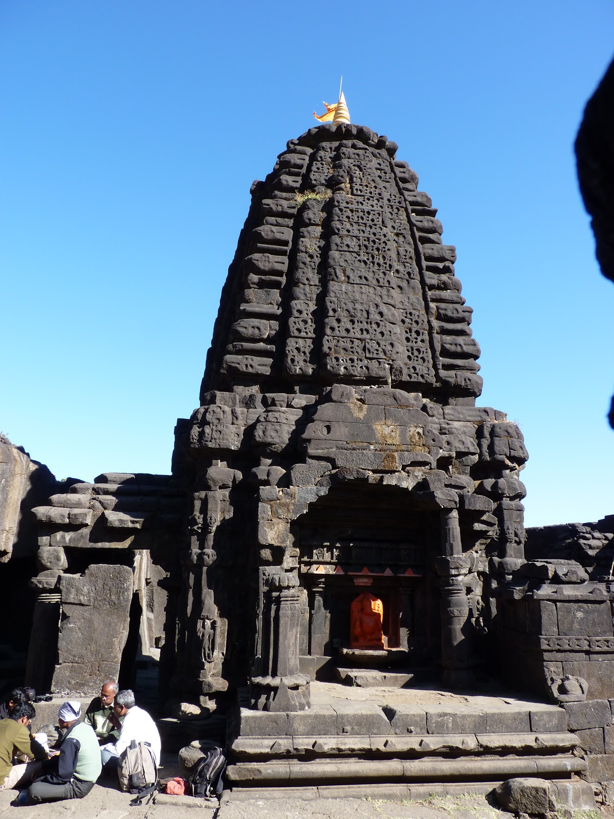
Harishchandragad fort (1424 m), Malshej
This is one of the mightiest of the hill forts, situated in a remote location. Travel from Kalyan to Malshej ghat and get down for Khireshwar near a dam (bund cum road). A broad path goes up to the Tolar Khind. A long flat walk leads to the temple.
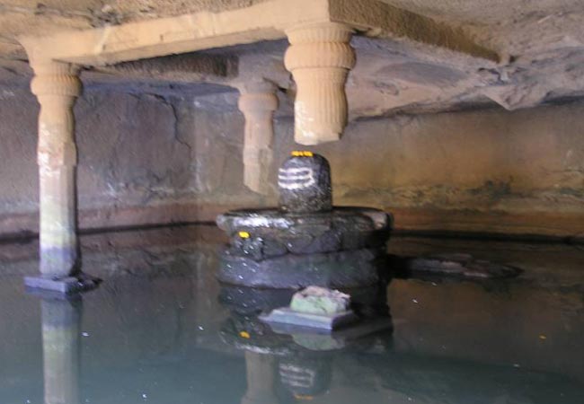
This hilltop has a large water reservoir and a long chain of Brahamanical caves. There is a beautiful temple with water and shelter. Next to the temple is a huge carved out room with a lingi in the centre of a water pond. The actual top is about 100 m further up from the temple and commands a view of the Nane ghat region. On top, a km to the east of the summit is the Bale Killa, with decaying walls and blown up cisterns.
Above, 2 km to the northwest is Konkan Kada. It is a huge semi circular rock wall of about 400 m and is a most beautiful sight. A light object thrown from the top is blown upwards by the strong wind from the semi circular basin.
Harishchandragad surrendered to the British in May 1818. Col. Sykes has written about viewing of perfectly circular vividly coloured rainbow on the edge of the Konkan Kada in mid May. Konkan Kada is a trekker's delight and the experience long a life time.

My friend Maruti Walunj at Konkan Kada
-
cialis satin al eczane
cheap propecia no prescription The Women s Contraceptive and Reproductive Experiences model is recommended for use by African American women to assess the risk of breast cancer
-
Ghargad (962 m), Igatpuri
Ghargad is in the centre of the range and is difficult to climb. Travel from Igatpuri to Nashik and getdown at Wadhiware phata on the way. Walk to the base of the fort via Wadhiware village (7 km). Follow a rocky staircase, which is blown off in some palces, to reach the top.
A long tunnel at the base of the rocky massif is a mystery and no one knows its length. After descending walk towards right, all along the ridge, to Ambli a rocky peak, to get an excellent view of the Trimbakeswar region. Thumb like 100 m pinnacle Dangya is on the left when one approaches the Ghargad.
 Posting Permissions
- You may not post new threads
- You may not post replies
- You may not post attachments
- You may not edit your posts
-
Forum Rules


 Reply With Quote


Bookmarks